Identify Sites With Clusters of Road Traffic Collisions Automatically
Improve road travel safety with KeyACCIDENT, UK’s leading traffic collision and casualty analysis system. KeyACCIDENT is a robust software package through which you can identify clusters of collision records and do detailed analysis to detect collision patterns and possible causes. Easily produce useful diagrams or comprehensive statistical or narrative reports to inform decisions about road or site improvements—and then automatically monitor those sites on an ongoing basis.
Platform Compatibility
We strive to keep our products compatible with the latest operating systems and platforms. Find the latest product compatibility information for Transoft products.
English
What Makes KeyACCIDENT Unique
Gain a deeper understanding of where and when road accidents happen
People’s ability to travel safely on roads is a priority across the region. With KeyACCIDENT’s sophisticated database and search functions, cities and local governments can better understand where and when road traffic collisions happen. KeyACCIDENT’s quick and efficient data capture is compliant with Department for Transport’s STATS19.
Make smarter traffic and infrastructure decisions to proactively prevent problems
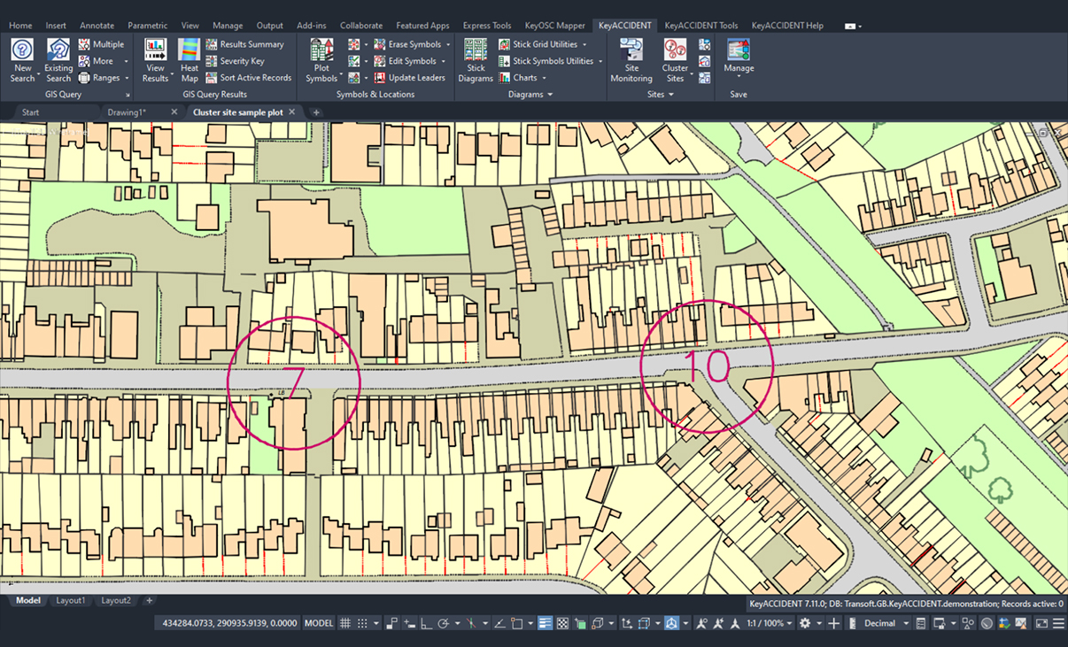
With KeyACCIDENT, it’s simple to search geographical areas for collision and casualty data, so you can identify clusters of collisions and investigate potential treatable sites. Once safety schemes at locations have been implemented, KeyACCIDENT allows you to monitor the locations and other sites of interest, and to track area-wide progress towards casualty reduction targets.
Save time with rapid search functions and user-friendly tools
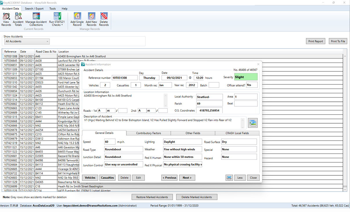
Multiple sites can be found quickly so that your time can be spent on the detailed analysis, rather than on the searching. KeyACCIDENT’s easy-to-use tools can handle simple or complex data analysis, and collision and casualty data can be sorted by a variety of attributes, including sites with highest rates or most recent collisions, or incidents involving pedestrians, motorcycles, or adverse conditions. Manage data through the database module or the geographic module. A separate data entry module also allows you to create individual records.
Produce compelling reports and collision diagrams
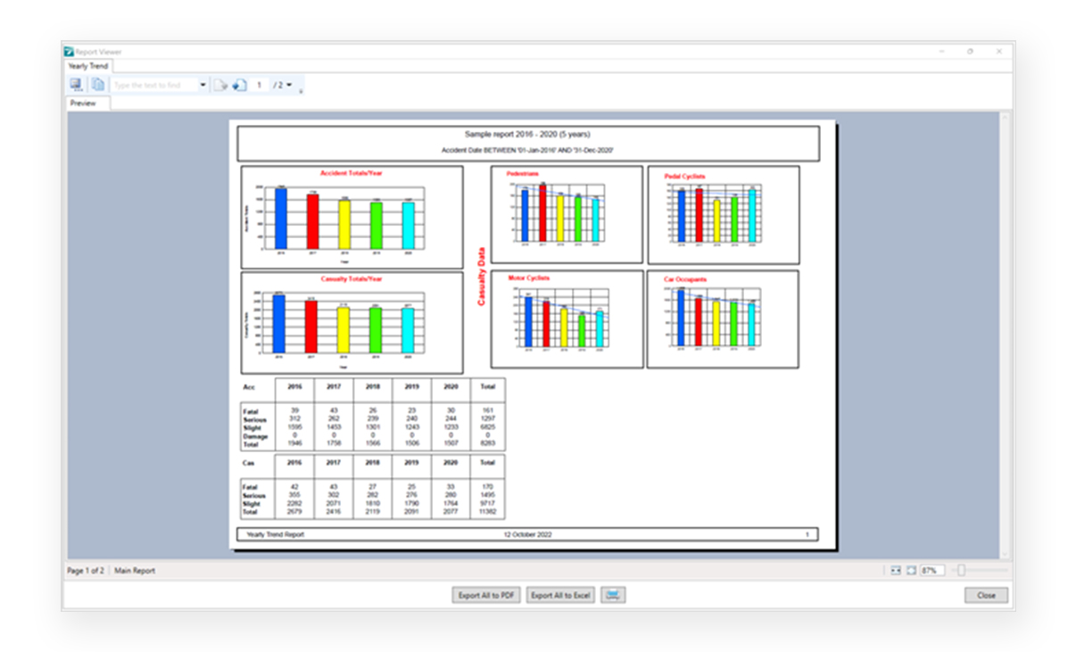
KeyACCIDENT’s helpful features include the ability to easily produce collision reports and graphic representations of the collision and casualty data within a search area. You can also choose from more than 50 graphs, charts, and statistical and narrative reports that are automatically generated from your selected data—or create your own with the Cross Tab report.
Features
Accurate Data Validation, Analysis and Reporting
KeyACCIDENT is a robust software package through which you can identify clusters of collision records and perform detailed analysis to detect collision patterns and possible causes.
- Easily search geographical areas for road traffic collisions
- Handle complex searches and generate 50+ different reports
- Identify collision cluster sites to allow for closer safety monitoring
- Validation checks are compliant to STATS19
Explore Features
Efficient Data Management
The database module allows for the smooth management of collision data as well as advanced interrogation of the database and production of extensive reports.
Data Entry
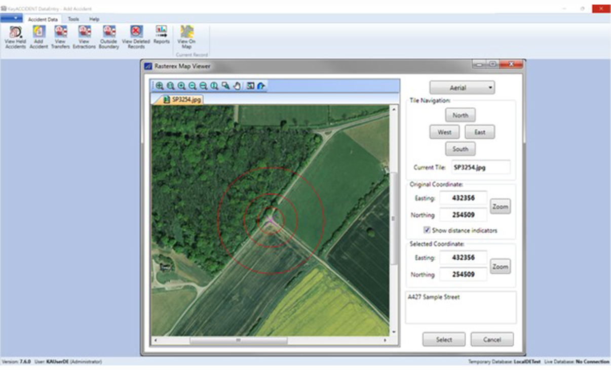
The data entry module allows for the creation of individual reports. With interactive maps you can locate the site—and Ordnance Survey coordinates are automatically inserted for each record. Collisions can be located to within one metre of the incident location. Validation checks are compliant to STATS19.
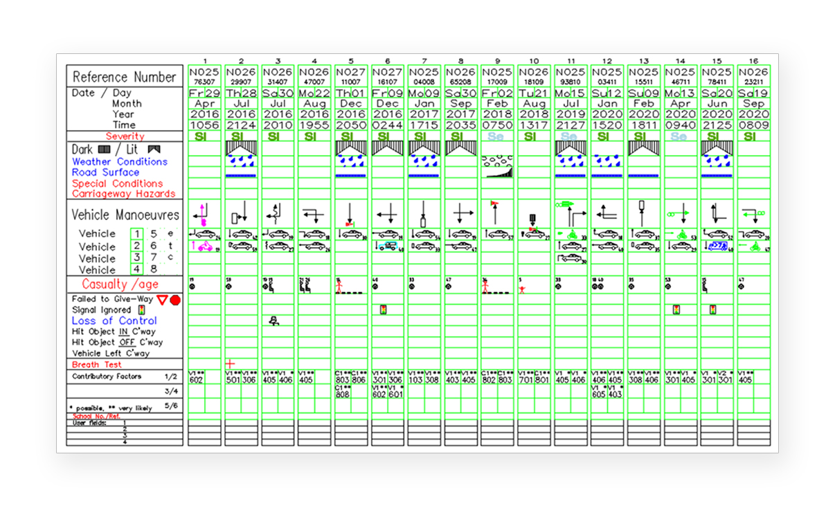
Stick Diagram Creation
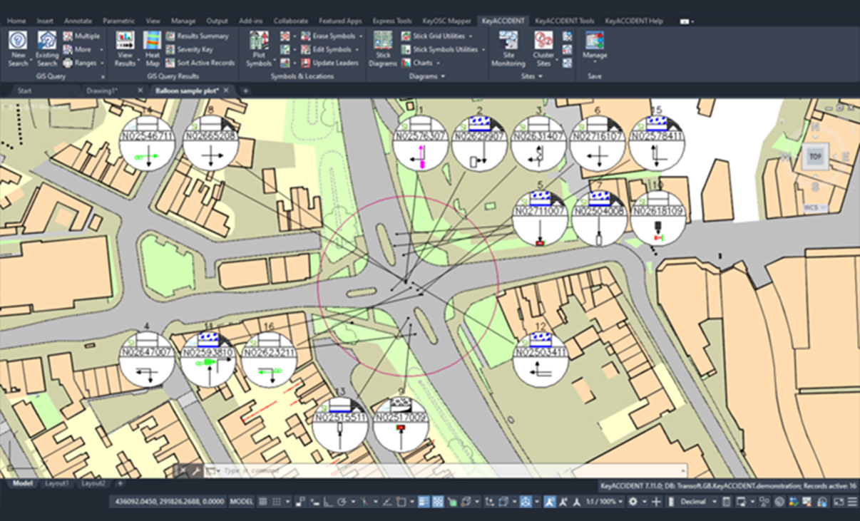
Generate ‘stick diagrams’ to show details of a geographic or database search; then sort them to show collisions with common attributes. These diagrams can be produced in a grid or to annotate a geographic search. They can be grouped together or drawn individually with a leader pointing on a map to the recorded location of the collision.
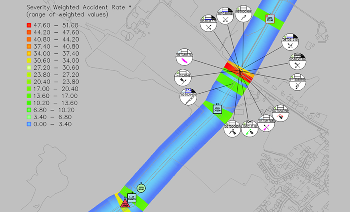
Heat Mapping
With the heat mapping function, you can show concentrations of accidents clearly, with colours representing severity rates or rates per million vehicles annually.
Extensive Reports
KeyACCIDENT includes more than 50 reports, graphs, and charts that can be produced automatically. For example, table reports can be generated by selecting any field combination from the accident, vehicle, and casualty tables. Summaries can be produced to compare norms throughout the whole area.
GIS Searching and Balloons
Enquiries can be made geographically with the GIS module, using circular, rectangular, irregular polygon, buffer, or whole-view search areas. Searches can also use other boundaries, such as District and Local Authority areas. Diagrammatic collision symbols can then be displayed automatically. If you’re using KeyOSC Mapper, you can include the latest OS Mastermap® mapping.
Site Analysis
With KeyACCIDENT’s sophisticated search functions, you can identify sites automatically with clusters of road traffic collisions. Ranking tools can prioritise sites with more recent collisions or the highest accident or casualty severities.
What’s New in KeyACCIDENT
New features, fixes, and other improvements built specifically with your feedback.
Get all the benefits of the latest release by upgrading your software.
Licensing Options
Transoft offers a range of licensing options to help small, sole proprietorships right on up to the largest multinational organisations meet their transportation design and analysis needs.
User Subscription License is a model where a set number of Subscribed Users are assigned dedicated access to the software through their unique logins for the duration of the license term. The software can be installed and used by a Subscribed User on multiple workstations.
Each Subscribed User represents one individual and their login and password, which cannot be shared with other users. Software activation is an easy process and can be done over the Internet.
Why Choose the User Subscription License Option
User Subscription License offers a cost-effective way for small businesses to start with one user and grow by adding additional users. For larger organizations, it will offer more flexibility in user administration and management via the My Transoft Portal. Furthermore, it can easily handle scalability and budgeting as per the business needs defined by the number of users.
Key Benefits of User Subscription License
- Automatic updates, new features, and content
Bug fixes, compatibility, and new version releases. - Easily manage your changing business needs
With enhanced scalability and user management. - Install the software and log in from anywhere
Access your workstation, laptop, or personal desktop. - Unlimited technical support
Receive premium assistance for all your deployments and technical support needs. - Invitations to learning-focused webinars
Attend learning-focused webinars from our product experts and learn how our software can help streamline design processes. - Flexible user license options
Choose from single to multiple user packages to meet your business needs. - Simple user administration
User Management can be performed in the My Transoft Portal, via invitation links or by Identity Provider Single Sign-on with User Provisioning.
Have more questions about User Subscription? See the FAQ here.
Team Subscription License is a license option that is intended to support casual or occasional users of the software. The size of a Team Subscription License is represented as a number of allocatable seats.
Why Choose the Team Subscription License Option
While User Subscription Licenses are better for dedicated users, Team Subscription Licenses can be a good complement to these if your organization has occasional, less heavy users of the software.
How it Works
Each user of a Team Subscription License must have an account in the My Transoft Portal to request a license. Internet access is required for this process.
When an end user starts the software product on their workstation, the software will connect to the My Transoft Portal and will determine if any of the seats are available. If a seat is available, it will be allocated and dedicated to that end user who will have unrestricted access to it for 24 hours. At the end of the 24-hour period the seat allocation will automatically expire, and another user will be able to claim it.
Once all the Team Subscription License seats are allocated at a given time, no other end user will be able to use that license until the 24-hour period expires and one of the seats is automatically deallocated.
Key Benefits of Team Subscription License
- More flexibility for your team members
Allows access to software for casual users without having to spend on dedicated licenses for all users. - Less administrative effort by IT
Easy access to software for casual users without IT having to allocate or transfer licenses amongst team members, self-administered by users with automatic 24-hour lock. - Combined Team & User Subscription option
Flexibility of mixing plans according to the needs of different user types. - Automatic updates, new features, and content
Bug fixes, compatibility, new version releases, or vehicle guidelines are automatically available to you. - Easily manage your changing business needs
With enhanced scalability and user management. - Install the software and log in from anywhere
Access your workstation, laptop, or personal desktop with Single Sign-on. - Unlimited technical support
Receive premium assistance for all your deployments and technical support needs. - Invitations to learning-focused webinars
Attend learning-focused webinars from our product experts and learn how our software can help streamline design processes. - Simple user administration
User Management can be performed in the My Transoft Portal, via invitation links or by Identity Provider Single Sign-on with User Provisioning.
Transoft Support
We take pride in delivering complete customer satisfaction. Get help with products, downloads, technical support, and more.
My Transoft Portal
Transoft's product enhancements are periodically released to provide access to new features, fixes, and security updates. For many products, you can find these updates and download them directly from My Transoft Portal.
Software License Agreement
For information on terms and conditions detailing the usage of our software, please refer to Transoft’s Software License Agreement (SLA).
Software FAQ
Search our extensive product knowledgebase that address some of the most frequently asked questions regarding Transoft‘s software.
Help Desk
Find answers to your issues on a variety of topics or request Technical Support. Get help with downloading and installing your software, managing your account, product compatibility and much more.
Licensing Options
Transoft offers a range of licensing options to help small, sole proprietorships right on up to the largest multinational organisations meet their transportation design and analysis needs.
Request a Quote
Thank you for your interest in KeyACCIDENT. Fill out the form to receive information on purchasing and licensing options or if you have questions in general about the software.
On business days, you can expect a response within 24 hours of your request.